Oregon's Most Dramatic Skyline You've Never Hiked Under
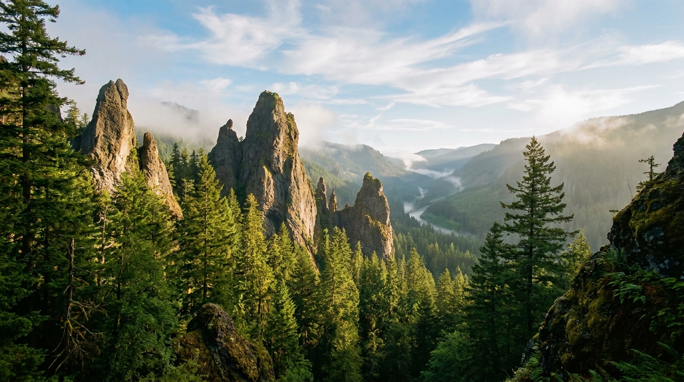
There's a ridge in the western Cascades, about 80 miles southeast of Salem, where a dozen volcanic rock towers rise from old-growth forest like something out of a fantasy novel. The spires of the Menagerie Wilderness — Cathedral Rock, Rooster Rock, Rabbit Ears, The Witch's Hat — are among the most striking geological features in the Oregon Cascades, and nearly every hiker who drives past on US-20 doesn't realize they're there.
That obscurity is the Menagerie's gift. This 4,800-acre wilderness designated by Congress in 1984 sees a fraction of the foot traffic of the Three Sisters or Opal Creek areas, yet it delivers scenery, solitude, and wildlife encounters that rival anything in the central Cascades. If you've exhausted the marquee trails and want something genuinely different — and closer to the Willamette Valley than you'd expect — the Menagerie belongs on your list.
The Wilderness at a Glance
The Menagerie Wilderness sits within the Willamette National Forest on the north side of the South Santiam River canyon, straddling the Highway 20 corridor between Sweet Home and Santiam Pass. The wilderness contains several distinct trail systems, but most visitors access it via the Rooster Rock Trail, which is the primary corridor into the rock formations that give the area its name.
The spires and pinnacles of the Menagerie are andesite volcanic plugs — the eroded cores of ancient volcanic vents — left standing after softer surrounding rock wore away over millions of years. They range from 20 to 200 feet tall, and several are popular technical climbing routes. Hikers and backpackers don't need a rope; you get the full visual experience from the trail without any vertical exposure.
Wildlife in the Menagerie is diverse and often visible. Roosevelt elk move through the old-growth Douglas fir and western hemlock forests year-round. Black bears are present at higher densities than many expect for such a small wilderness. Ravens, peregrine falcons, and osprey nest on the rock formations. In summer, the lower forest holds ruffed grouse, and the high country sees occasional mule deer.
The Rooster Rock Trail: Your Primary Route
Trailhead: Rooster Rock Trailhead, off US-20 approximately 5 miles east of Cascadia State Park. Look for the small brown wilderness sign on the north side of the highway. Parking is limited to 4 to 6 vehicles — arrive early on summer weekends.
Distance: 5.5 miles roundtrip to Rooster Rock viewpoint; 8.4 miles roundtrip to Cathedral Rock
Elevation gain: 2,200 feet to Rooster Rock; 2,700 feet to Cathedral Rock
Difficulty: Strenuous. The trail gains elevation aggressively in the first 2 miles with few switchbacks.
The trail begins in classic western Cascades second-growth before quickly entering old-growth forest as it climbs the ridge. The canopy of 200 to 400-year-old Douglas firs and western red cedars along the creek bottoms gives way to more open hemlock and vine maple as elevation increases.
At approximately mile 2, the rock formations begin to appear on your right — startling at first, as the spires emerge above the forest canopy without warning. Rooster Rock is the most dramatic and most recognizable feature: a 100-foot andesite needle rising from a ridgeline notch with views south across the South Santiam canyon and east toward Santiam Pass and the Three Sisters.
The trail continues east from Rooster Rock along a high ridge with increasingly open terrain and wider views. Cathedral Rock — a broad cluster of interconnected spires — anchors the east end of the main ridge and provides the best all-direction vantage point in the wilderness. On clear days you can see from Mount Jefferson north to Three Fingered Jack, with Hoodoo Butte visible to the east.
Overnight Options: Where to Camp
The Menagerie isn't set up for the kind of high-alpine base camping you'd find in the Three Sisters or Wallowa wildernesses. There are no lakes, no established campsites, and water sources are limited above the first mile of trail. That said, overnight trips are entirely viable and rewarding — especially for backpackers who want to watch sunrise and sunset light play on the rock formations without sharing the ridge with a dozen other day hikers.
Best camp locations:
- Below Rooster Rock (approx. mile 2.0): Flat ground exists in the forest just below the first major rock outcrop. A small seasonal creek runs here through July in normal snow years. Camp here and be on the ridge for sunrise with an easy pre-dawn hike.
- East ridge saddle (approx. mile 3.5): A wind-sheltered saddle between two spire clusters offers the best high camp, but water requires a quarter-mile drop to a seasonal drainage. Carry extra water from below. This is the best position for sunset and early morning light on the rocks.
Practice Leave No Trace principles strictly in the Menagerie. The small wilderness sees relatively low impact and the old-growth forest floor is fragile. Camp on durable surfaces (rock slabs or established flat areas), hang food with a bear canister or PCT hang (bears are active here), and pack out all waste.
Water and Conditions
The lower trail has year-round water. Upper trail sources — seasonal drainages above mile 1.5 — can dry up by mid-July in low-snowpack years. Plan to carry 2 to 3 liters from the reliable lower creek if you're heading for a high camp in summer. A Sawyer Squeeze or similar lightweight filter is sufficient — no chemical treatment issues with this water.
Trail conditions are generally excellent from late May through October. Snow can linger on the high ridge through mid-June in heavy snow years. The lower old-growth sections are hikeable year-round, though winter access requires caution on ice.
Getting There
From Salem: Take US-20 east through Sweet Home approximately 45 miles. The Rooster Rock Trailhead is on the right (north) side of the highway, marked by a small wilderness sign. No fee or permit is currently required for day use or overnight camping in the Menagerie Wilderness.
From Bend: Take US-20 west over Santiam Pass approximately 75 miles. The trailhead will be on your left (north) side, roughly 5 miles west of Cascadia.
Cell service ends before you reach the trailhead from either direction. Download your maps, GPS routes, and weather forecasts before leaving town. The Willamette National Forest Sweet Home Ranger District (541-367-5168) can provide current trail conditions by phone.
Why It's Worth the Scramble
The Menagerie Wilderness offers something rare in a state crowded with spectacular scenery: complete solitude in genuinely dramatic terrain, within two hours of Oregon's largest population centers. You won't see another backpacker at your high camp on most summer weeknights. You'll fall asleep to owls calling through the old-growth and wake up with the spires glowing in first light, with the elk country of the South Santiam spread below you.
For hunters and outdoorsmen who think of backpacking as a scouting tool as much as a recreational pursuit — this wilderness holds elk. The Menagerie is in the Santiam hunting zone, and a summer backpack trip doubles as recon for the archery opener. The old-growth basins below the spires are exactly the kind of structure that holds Roosevelt elk through the summer, and a weekend spent up here with binoculars will teach you things about that ground that no map can show.
Get up there before everyone else discovers it.