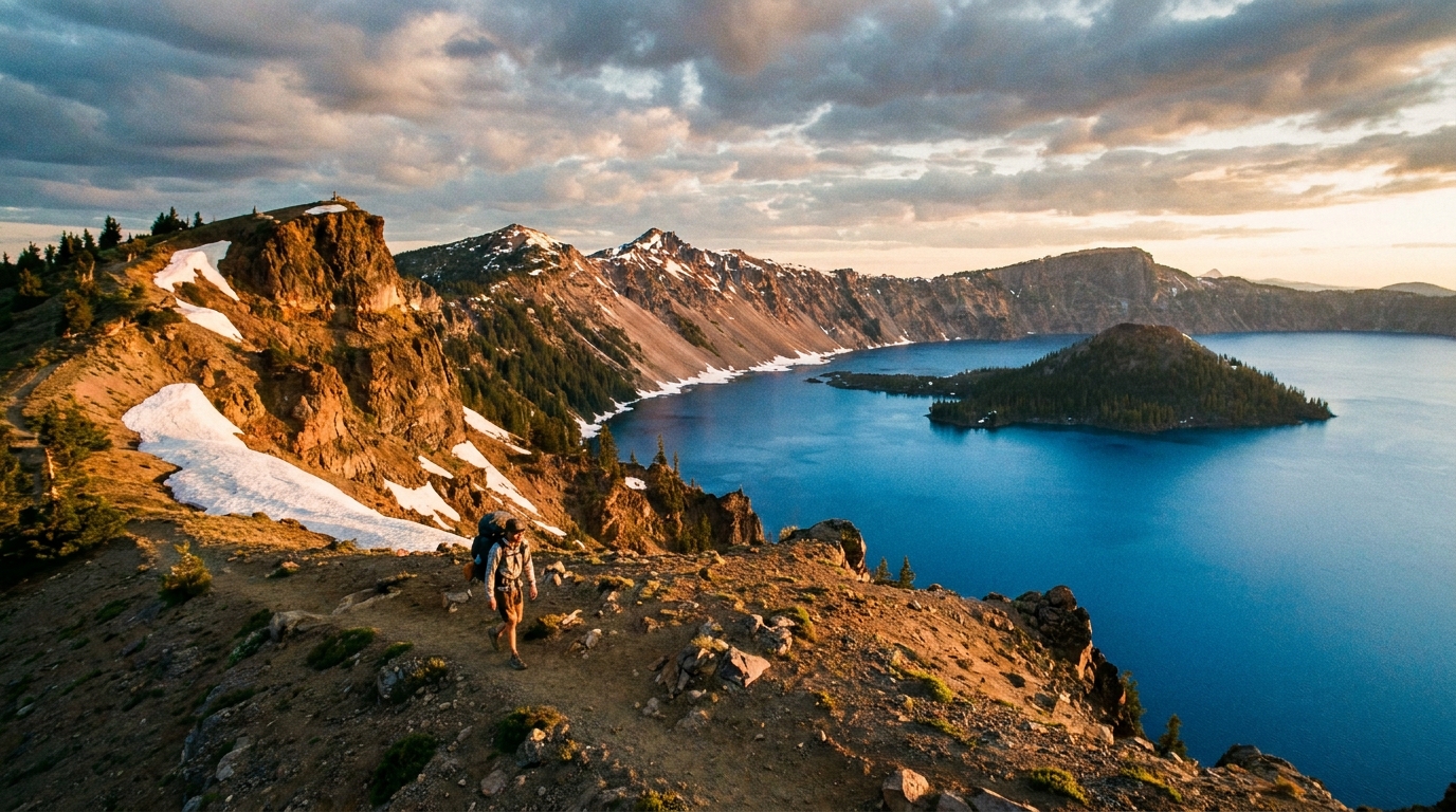
There is no body of water in North America that looks quite like Crater Lake. Formed roughly 7,700 years ago when Mount Mazama collapsed after a catastrophic eruption, the caldera filled over centuries with nothing but rain and snowmelt — no inlets, no outlets, just sky water. The result is the deepest lake in the United States at 1,943 feet, and a blue so saturated it looks digitally enhanced. Hiking the rim is a bucket-list experience. Backpacking it — camping above the caldera with that impossible color below you at dusk — is something else entirely.
The Route: Crater Lake Rim Trail Overview
The Crater Lake Rim Trail is a roughly 33-mile loop around the caldera rim in Crater Lake National Park in southern Oregon's Cascade Range. The trail varies between 7,000 and 8,200 feet elevation, with numerous viewpoints, volcanic features, and camp areas along the way. It is not a technically difficult route — there are no scrambles, no glacier travel — but the elevation, sun exposure, and lack of water sources require serious preparation.
Most backpackers complete the loop in 2–3 days, covering 10–17 miles per day. A leisurely 3-day, 4-night itinerary with time for photography and side explorations is ideal for most hikers.
Permits and Regulations
Crater Lake National Park requires a backcountry permit for all overnight camping. Permits are available at the Steel Visitor Center (open year-round) or the Rim Village Visitor Center (summer only). Permits are free but required and must be obtained in person — no advance online reservations for most of the trail. Show up the morning of your planned departure. Popular summer weekends can see permit limits hit by mid-morning, so arrive early.
Camping is permitted in designated zones, typically at least 100 feet from the rim edge and 200 feet from water sources. Wood fires are prohibited on the rim — bring a stove. Pack out all waste; the park is pristine and the rangers enforce it.
When to Go
The rim is typically snow-free from mid-July through October, with peak conditions in August and early September. The park receives massive snowfall — often 40–50 feet per winter — and snow can persist into July on north-facing sections. Late September into early October is often the best time to hike: fewer crowds, crisp air, the first autumn colors on the volcanic slopes, and the lake at its most mirror-like before fall winds arrive. Avoid the Fourth of July weekend and mid-August peak crowds if possible.
Late June hiking is possible but requires micro-spikes or traction devices; check current conditions with the park before committing.
Water: The Critical Challenge
Water is the defining logistics challenge of the Crater Lake Rim. The lake itself sits far below the rim trail — 1,000 feet of sheer cliff in most places — and is not accessible from the trail except at a few very specific points (Cleetwood Cove trail on the north rim is the only legal trail to the water). There are no reliable streams along most of the rim.
Water sources to know:
- Cleetwood Cove Trail (north rim): The only paved trail to the lake surface. If your itinerary takes you past here, fill up. This is the most reliable source on the route.
- Seasonal snowfields: In early season (July), patches of snow on north-facing slopes can be melted. By September, these are typically gone.
- Park headquarters area (Munson Valley): If you're starting from the Steel Center, fill up maximally before heading out.
Plan to carry 3–4 liters at all times on dry sections. Dehydration at 8,000 feet in summer sun is a real risk, especially on exposed south-rim sections. A Sawyer Squeeze or Katadyn BeFree filter is essential. Do not count on snowmelt in late summer.
Recommended 3-Day Itinerary (Clockwise from Rim Village)
Day 1: Rim Village to Kerr Notch (~11 miles)
Start at Rim Village (7,100 ft) and head clockwise (counterclockwise takes you into more sun exposure early). Pass Garfield Peak (optional 1.7-mile RT spur to the highest viewpoint on the south rim at 8,054 ft — absolutely worth it). Traverse the east rim past the Phantom Ship Overlook and drop into the designated camping zone near Kerr Notch. Spectacular sunset views over the lake from this section.
Day 2: Kerr Notch to North Junction (~10 miles)
Continue north along the east rim past Cloudcap — at 8,065 ft, the highest point on the rim drive and trail. Detour down to Cleetwood Cove (1-mile, 700-ft descent) to fill water at the lake before continuing. The north rim offers some of the best views of Wizard Island, the 763-foot cinder cone rising from the lake. Camp in the north rim zone near the junction with the Bald Crater Loop.
Day 3: North Junction to Rim Village (~12 miles)
The longest day, but the west and south rim trail is spectacular with views across the full width of the caldera. Pass Discovery Point — where first non-Native sighting of the lake was recorded in 1853 — and finish back at Rim Village. If legs are willing, the Watchman Lookout spur (0.8 miles each way) at 8,025 ft is the best overall perspective of the entire caldera.
Gear Considerations at 7,000–8,200 Feet
Despite summer daytime temperatures that can hit the 70s and 80s, nights on the rim drop quickly into the 30s by late August and September. Bring a sleeping bag rated to at least 25°F. Sun exposure on the rim is intense — sun hat, UV-blocking layers, and SPF 50+ sunscreen are not optional. A wind layer is essential; the caldera generates its own thermals and afternoon gusts can be strong.
- Layering system: base layer, insulating mid-layer, waterproof shell
- Sleep system: 25°F bag minimum, quality sleeping pad
- Water capacity: minimum 3L, ideally 4L on-body capacity
- Navigation: Gaia GPS or CalTopo downloaded offline — cell service is minimal
- Bear canister: not required but recommended; black bears are present in the park
- Trekking poles: helpful on descent sections, especially Cleetwood
Why Crater Lake Belongs on Your Backpacking List
The Cascades are full of outstanding backpacking routes — the Three Sisters, the Eagle Cap, the Wallowas. Crater Lake is different. It's not a wilderness in the traditional sense; it's a national park with paved roads and boat tours. But sleeping above that caldera, watching the light change from steel-blue to orange on the volcanic walls, and waking up to absolute silence at 7,500 feet — there's nothing else quite like it in Oregon. Make the trip while the permits remain free and the trail remains quiet.